The Ottawa-Bonnechere Graben

Our very own graben

Home
What the heck is a graben?
Where can we find grabens?
Our very own graben
And it's Significance?
Way cool facts!
Bibliography
Fig. 7:This diagram shows the periods in deep time
timescale2.jpg
Image from: http://geoscape.nrcan.gc.ca/ottawa/time_e.php

Located in Ontario, in the Ottawa Valley, The Ottawa-Bonnechere graben "was formed hundreds of millions of years ago [approximately 175 million years ago during the Mesozoic period] and is associated with the breakup of an ancient continent." (Eyles, 2002).  It is known as a 'failed rift'.  A failed rift is a graben that no longer widens and grows larger over time.  A rift which fails to grow any further will eventually fill with either water or some type of sediment.   

Fig.7:Map of Ontario shows location of the graben
ontario-map.gif
Image from: geology.com/canada/ontario-map.gif (modifications made by author)

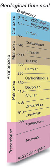
Fig. 8: The shape and location of the graben
graben4.jpg
Image from: http://geoscape.nrcan.gc.ca/ottawa/time_e.php

It is located along the Gatineau Hills, running Northward from Ottawa and Westward from Montreal.  The graben runs approximately 35km wide and reaches depths of 75 feet.  Like similar grabens around the globe (the East African Rift Valleys for example), Alkaline Igneous rocks can be found at the Ottawa-Bonnechere Graben.  Sedimentary rocks from the Paleozoic era (from 544 to 250 million years ago) are also found there as well as in the surrounding St. Lawrence Valley (Rimando and Benn, 2005).   


Seismicity in the Ottawa-Bonnechere Graben and Surrounding Area:  This table shows us that these plates are continuously moving and are still active.  We see that not all earthquakes have been damaging or even threatening, though we do know they are there!
 
 
Fig. 9: Table of seismicity surrounding the graben. 


Location

Magnitude

Date
Montreal
5.8

September 16, 1732

Ottawa

--

July 12, 1861
Timiskaming
6.2
November 1, 1935
Cornwall-Massena
5.6
September 5, 1944
Cornwall
3.3
July 4, 1981
Timiskaming
4.3
August 13, 1982
North Gower (near Ottawa)
4.1
October 11, 1983
Timiskaming
5.2
January 1, 2000

Table information from: Rimando, Rolly E, and Keth Benn, 2005, http://www.sciencedirect.com/science_ob=ArticleURL&_udi=B6V9X4FNDS431&_user=10&_rdoc=1&_fmt=&_orig=search&_sort=d&view=c&_acct=C000050221&_version=1&_urlVersion=0&_userid=10&md5=1ab79f1c6fe07817f3435dd8fc617a78

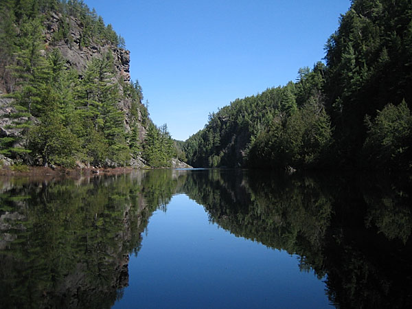
Fig.10:The Barron Canyon fault crossing the graben
graben5.jpg
Image from: Bob & Diana McElroy. www.mcelroy.ca/bushlog/images/10c-3153.jpg


There are many fault lines running perpendicular to and across the graben as well.  The Barron Canyon is an examples of one of those faults.